Chilika Lake, along the northeastern margin of the Bay of Bengal in Odisha, is Asia’s largest brackish-water lagoon. The lake is separated from the open waters of the Bay of Bengal by a series of long sandy barriers about 71 kilometres long and 150 metres wide.
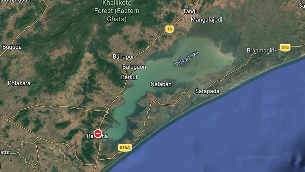
How did this unusual landscape form? What natural forces shaped Chilika Lake?
To investigate, Anil K. Gupta, Abhijeet Santra and Biswajit Palar from IIT Kharagpur built a bamboo drilling platform, mounted it on two boats and took it to the northwestern part of Chilika Lake. At a water depth of one metre, they used an augur and rotary drill to retrieve a sediment core that was nearly sixteen metres long with a nine-centimetre diameter.
The core was taken to the Geochemistry Laboratory at IIT Kharagpur, where the researchers split it lengthwise into two halves – one was used for research and the other was for archiving purposes.
For the detailed geological study, the researchers sliced samples every centimetre from the half that was reserved for research. They selected 17 such samples from specific depths along the core for accelerator mass spectrometry radiocarbon dating at IUAC, New Delhi.
Researchers at IUAC pretreated the samples to isolate pure carbon. Carbon dating revealed that the core represented sediments as far back as 28000 years ago. The topmost sediment dated from 452 years before 1950. The researchers converted the radiocarbon dating results into calendar years to develop a timeline for the sediment layers.
The grain size analysis of 500 samples was performed at IISER Kolkata. Changes in grain size provide clues about changes in sediment transport dynamics, hydrological regimes and the sources of the sediments.
To understand the geological history of Chilka Lake, Prasanta Sanyal and Manoj Kumar Jaiswal at IISER Kolkata facilitated the analysis of carbon isotope data, as well as that of major and trace elements in the samples with the help of a stable isotope analyser and X-ray fluorescence.
From these multiple lines of evidence, as well as with evidence from previous research related to climate change, including changes in monsoon precipitation and sea level changes, the researchers at IIT Kharagpur started putting the puzzle together.
Based on the changes in the grain size of the sediments, and the proportion of sand, silt and clay, the researchers could identify four broad shifts in the status of the core’s location.
The deepest sediments, from between 28,000 and 23,500 years ago, were dominated by sand. Since this was the time of glaciation on the earth, the sea was tens of kilometres away from the location of the core. Moreover, the monsoon was weak then. So, the older quartz-rich beach, coastal plain, and possibly shelf sediments might have been reworked by the waters of the Mahanadi delta and fluvial action. The composition of trace elements and oxides in the samples supported this inference.
Perhaps there was no big lake at that time. Only a few ponds were scattered in the area, say the researchers.
The period of the last glacial maximum was from 23,500 to 19,000 years ago. The sea level would have lowered even more and the conditions would have become more arid due to a weaker monsoon. The fraction of sand in the core representing that time decreased and silt increased due to the settling down of the suspended particles. The composition of the elements and oxides suggested that the sediments were brought in by the Mahanadi deltaic system from the cold weathering of the crystalline rocks of the Eastern Ghats.
From about 19,000 years ago till 11,700 years ago, there was progressive deglaciation and increasing monsoon rains. The sea level, however, did not rise enough to reach the present shoreline.
The clay fraction in the sediments of the core, representing the period around 15000 years ago, had higher amounts of clay, till about 14000 years ago, due to an increase in monsoon activity. Then the clay fraction became moderate and silt started settling down, suggesting lower hydrological action. The composition of elements and oxides suggests the deposition of materials from the Eastern Ghats by the Mahanadi delta.
The Chilika basin seems to have evolved from a dry fluvial coastal plain to an increasingly waterlogged lagoon-type lowland during this period.
During the early Holocene, from about 11,700 to 9,000 years ago, the sea level rose further and the monsoon became stronger. The sediments in the core representing this time period show higher sedimentation rates. The composition of elements and oxides suggest that, besides the sources from the Eastern Ghats, there were some marine inputs as well.
Probably, there was marine transgression and the formation of an estuary at this time, say the researchers.
Between 8,400 and 7,100 years ago, the sea level reached or even exceeded present levels, inundating large parts of northern Odisha. The sediments of this period show more clay, moderate silt and very low sand fractions.
From 6000 years ago, the sea started receding. The sediments from Mahanadi and its tributaries contributed to the formation of a barrier from the sea The barrier formed over time from the south to the north with splits in between and the Chilika slowly started becoming a lagoon.
The sea level regression continued and it was around 2000 years ago that the Chilika Lake became approximately what it is today. The composition of the elements and oxides in the core representing this time show reduced inputs from the weathered rocks of the Eastern Ghats, suggesting that there was a brief dry spell around this time.
From 2000 years ago till now, the sediment source from the Eastern Ghats increased. Further evolution of the lagoon was controlled by the monsoon rainfall and by occasional cyclones.
This is not a definitive reconstruction of the history of Chilika. We are dependent on evidences from multiple proxies to piece together the evidence, say the researchers at IIT Kharagpur.
“Data from the examination of microfossil assemblages, palynological records, organic biomarkers, and isotopic tracers, would help improve the estimates of the timing and nature of these transitions, and the type of vegetation including the mangroves that existed in the Chilika in the past,” says Anil K. Gupta, IIT Kharagpur.
The research team at IIT Kharagpur plans to continue this line of investigations.
Chilika Lake supports the livelihoods of a large number of fishermen and people living around its shores. Chilika also attracts thousands of Siberian birds every winter, and houses a rich diversity of vertebrates and invertebrates. These research findings help us understand the natural forces that governed fragile coastal wetlands and guide efforts to protect their ecological and economic future.
Palaeogeography, Palaeoclimatology, Palaeoecology 703: 114269 (2026);
DOI: 10.1016/j.palaeo.2026.114269
Reported by Sanghamitra Deobhanj
Freelance science writer, Cuttack
The reports on this site are free-to-use for media houses in India


Leave a Reply